


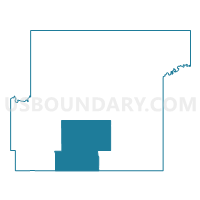
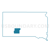
VTD - 7, Jackson County, South Dakota
About
Outline

Summary
| Unique Area Identifier | 667401 |
| Name | VTD - 7 |
| County | Jackson County |
| State | South Dakota |
| Area (square miles) | 209.36 |
| Land Area (square miles) | 209.18 |
| Water Area (square miles) | 0.18 |
| % of Land Area | 99.91 |
| % of Water Area | 0.09 |
| Latitude of the Internal Point | 43.48401960 |
| Longtitude of the Internal Point | -101.68598950 |
Maps

Graphs
Select a template below for downloading or customizing gragh for VTD - 7, Jackson County, South Dakota


Neighbors
Neighoring Voting District (by Name) Neighboring Voting District on the Map
- VTD - Allen, Bennett County, SD
- VTD - Green Valley voting precinct, Jackson County, SD
- VTD - Interior voting precinct, Jackson County, SD
- VTD - Long Valley precinct, Jackson County, SD
- VTD - MR 26, Bennett County, SD
- VTD - precinct 3, Jackson County, SD
- VTD - Vetal, Bennett County, SD
Top 10 Neighboring County Subdivision (by Population) Neighboring County Subdivision on the Map
- Southwest Jackson UT, Jackson County, SD (1,626)
- West Bennett UT, Bennett County, SD (1,368)
- East Bennett UT, Bennett County, SD (992)